top of page

Urban Design Issues
Milton Keynes, Thomas Smith-Keary, 14045700
"How can retrofitted transport infrastructre create innovative & vibrant social spaces for people that impacts positevley on local identity?"
Design Objective 2
What
Provide welcoming and comfortable streetscapes designed for people long Midsummer Boulevard East allowing and giving reason for people to visit, to stay and to socialise.
Why
Due to Midsummer Boulevard East design, it is heavily orientated towards the car, with the majority of pedestrian activity being forced inside enclosed shopping malls. This has left the outside public realm particularly bleak and lifeless. Improving the public realm, offering more chances to sit, relax, linger and socialise will allow and encourage people to actually use the spaces outside.
How
DA 2.0: Humanising the car will dramatically reduce its impact on the site, in tangent with DOJ 3.0, the vast amounts of car parking spaces have been infilled and the main roads running through the site have been reduced in size allowing greater space for dedicated cycle lanes and pedestrian pavements.
On junctions, pedestrians and cyclists have priority, with the road line actually being broken allow greater ease of movement for those on foot.
DA 2.1: Secklow bridge is a local landmark and an eyesore, its bare concrete structure will be re-clad similar in style to the Mile End Bridge in Tower Hamlets, the road on it will be reduced in size freeing up space to allow dedicated cycle lanes and a pedestrian pavement. The bridge itself will also be draped in greenery with vines, shrubs and other plantings hanging and growing on the walls.
DA 2.2: The market area has been retrofitted considerably, the permanent market stalls have been removed and the square has been opened up underneath the bridge, lighting is obviously a concern has tried to be solved, firstly the removal of the permanent stalls itself allows natural light to flow into the space more easily, and greater lighting is also present. Skylights have also been added into the bridge ceiling, allowing light to reach deeper into the space when the sun is high in the sky, these are also lined with greenery and planting.
The space has als0 been turned into
mixed use, with space inside the concrete ramps being turned into bars and cafés, this will generate activity in the square with spillout space. One of the ramps has been used as a place for traders to store goods and stalls, the permanent stalls were often used to hold non perishable goods which they would otherwise need to bring themselves, access for them is also provided to load and unload via a street next to the the shopping centre on the north side.
DA 2.3: Providing plentiful and well designed opportunities for people to sit is vital to a good public realm and generating activity on it. Seating is situated in places where human activity is going to be present, using the edge effect as much as possible.
Seating is provided through a mix of seating types, in public squares movable seating is provided for the general public, with ledges spread around them to allow people to observe the streetscene in comfort. Parklets similar in form to those in San Francisco have also been placed around the site creating mini areas of public space.
DA 2.0: Retrofit the existing road network, reducing car capacity and increasing space for pedestrians and cyclists.
DA 2.3: Provide numerous well-placed and well-designed opportunities for people to sit, stand and, relax, with a mix of seating types and variations in building line
DA 2.2: Redesign the market, removing the permanent market stalls and creating a public square that is able to be used for a variety of functions and uses
DA 2.1: Retrofit Secklow Gate Bridge, recladding the bare concrete, reducing car capacity, and allowing pedestrians to utilise the bridge and creating social spaces and active frontages underneath it.


fig 137, Parklet in San Francisco (http://anthologymag.com/blog3/2013/04/12/san-francisco-parklets/anthology-mag-blog-outandabout-parklet-4/)
fig 139, Parklet in San Francisco, (http://rebargroup.org/category/doxa/projects/page/3/)
fig 135, Social space in Barcelona
fig 133, Variety of seating in Brighton


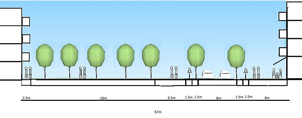


fig 118, residential street showing limited on-street parking. (author)
fig 119 (top left) street plan of central street in new perimeter blocks. (author)
fig 120 (bottom left), showing the plans location on site (author)
fig 121 (top right) street plan of smaller side street in new perimeter blocks. (author)
fig 122 (bottom right), showing the plans location on site (author)
fig 123 (top) street plan of street leading from Secklow bridge, adjacent to community gardens (author)
fig 124 (bottom left), showing the plans location on site (author)
fig 125 (right) street plan of Misummer Boulevard East (author)
fig 126 (bottom), showing the plans location on site (author)
fig 127 (left) and fig 128 (right), possible ideas of infilling excess pavement space in the street (PLANT*SE)
fig 129, view of the retrofitted Secklow Gate Bridge, reclad in yellow similar to Mile End Bridge. (author)
fig 130, view of Secklow Gate Bridge, an example of how the bridge could be physically greened wth hanging plants on the top of the bridge walls. (author)
fig 131, the underneath of Secklow Gate Bridge, showing spillout space. (author)
fig 132, the new public space around Secklow Gate bridge, showing the market in operation. (author)
fig 138, example of a parklet on midsummer boulevard creaitng a mini social space (author)
fig 136, benches in the market square, placed on the edge of the space overlooking activity (author)
fig 134, raised area of public space to create refuge from the street for people to relax with movable seating and ledges(author)
bottom of page